
Philippine Defense Today (Adroth.ph)
In Defense of the Republic of the PhilippinesSRDP opportunity to develop jammers for China’s GPS?
Wednesday , 12, November 2014 Self-Reliant Defense Posture Leave a commentMost modern smart munitions use a combination of GPS and Inertial Navigation Systems (INS) to achieve their phenomenal accuracy. Loss of one option, therefore, doesn’t completely negate the “smartness” of the weapon. Both, however, are needed to work as advertised.
Of the two options, the GPS component is most vulnerable to outside interference because it is susceptible to jamming, as the Russians have advertised in the past, and for which Saddam-era Iraq spent a fair amount.
From: http://www.scientificamerican.com/article/safeguarding-gps/
Indeed, it was the potential vulnerability of GPS to jamming that prompted Iraq to purchase a number of GPS jammers fromAviaconversiya Ltd., a Russian company that has been hawking GPS jammers at military hardware shows since 1999. The high-priced and high-powered GPS jammers offered by Aviaconversiya were said to be able to jam GPS signals for a radius of several miles. The Iraqi military used at least six of these high-powered GPS jammers, which cost $40,000 or more each, during the war. All six were quickly eliminated by U.S. forces over the course of two nights. Officials won¿t provide details, but considering the speed with which they tackled the problem, the Iraqi GPS jammers may initially have been somewhat effective.
 |
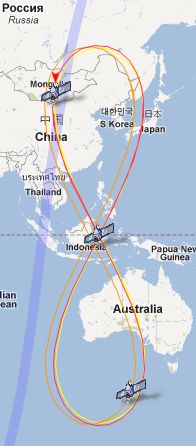
Photo from China Defence Blog
China actually has its own GPS-equivalent known as Beidou, which was composed of nine satellites as of 2011, flying over China, the Korean peninsula, the WPS, and Australia.
Photo below from: http://www.astronautix.com/craft/beidou.htm
 |
Isn’t it time for the AFP to acquire its own Beidou jammers?
Or better yet . . .
. . . develop its own as a medium-term SRDP initiative.
Concerned about North Korean use of the Chinese navigation system for its own smart munitions, South Korea is reportedly already looking into measures to jam the system. See the following paper written by researchers at Konkuk University, Seoul, South Korea.
At least some frequencies at which Beidou operates are known. The following text is from: http://gpsworld.com/signal-quality-of-galileo-beidou/
BeiDou M6. BeiDou satellites transmit navigation signals in three different frequency bands, all are located adjacent to or even inside currently employed GPS or Galileo frequency bands. The center frequencies are for the B1 band 1561.1 MHz, B3 band 1268.52 MHz, and B2 band 1207.14 MHz.
In 2012, China launched six satellites: two inclined geostationary space vehicles and four medium-Earth orbit ones, concluding in September (M5 and M6) and October 2012 (IGSO6). There have been further BeiDou launches in 2013, but these satellites’ signals are not analyzed here.
This would present an interesting opportunity to the proposed PH DARPA. This would just be the kind of competitive crowdsourcing effort that this organization could undertake, and leverage the following factors in its favor:
1. Compared to other projects (e.g., basics of air defense, ASW, etc.) this is NOT a critical, time-sensitive need. Therefore it is low-risk
2. There is a relative abundance of local engineering talent for such projects
Interested in exploring this opportunity further? Visit the following discussion at Timawa.net: http://www.timawa.net/forum/index.php?topic=38904.0